
Preview
CARTE NOUVELLE DE LA POLOGNE, Avant son demenbrement dirigee par Mr. Philippe…Censeur Royal, et Professuer d‘histoire; del Academie Royale des Sciences et belles-lettres d‘Angeri
Make a reservation for a visit Order a digital image of high quality 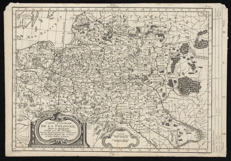
© Vytautas the Great War Museum Copyright policy
| Museum | Vytautas the Great War Museum |
| Fund | main |
| Exhibit type | žemėlapis |
| Field | kartografija, istorija |
| Primary account number | VDKM GEK 2303 |
| Inventory number | VDKM S 11225 |
| Measurements | aukštis – 28,5 cm plotis – 41 cm |
| Materials | litografinis popierius |
| Manufacturing technique | litografija |
| Author(s) | |
| Date | XVIII a. |
| Location | Prancūzija |
Description
| Exhibit description | Lenkijos žemėlapis. XVIII a. Šį prancūzų kartografo Gijomo de Boplano Lenkijos žemėlapį perdirbo M. A. Moitėjus, išraižė Ž. E. Ž. Valetas ir 1787 m. Paryžiuje išleido E. A. F. de Pretotas. Žemėlapio dešinėje pusėje, viršuje yra paginacija N 75. |
Other titles
Main title
| Title | Language | Type | Date | |
|---|---|---|---|---|
| CARTE NOUVELLE DE LA POLOGNE, Avant son demenbrement dirigee par Mr. Philippe…Censeur Royal, et Professuer d‘histoire; del Academie Royale des Sciences et belles-lettres d‘Angeri | more information... |
Information on inventory
| Data author | Arvyda Navickienė |
Author's rights of the exhibit
| Owner of author’s rights | Vytauto Didžiojo karo muziejus |
 |  | |  |